Environmental Change Investigated at the Taita Research Station in Kenya
Earth Change Observation Laboratory, a research group operating at the Taita Research Station in Kenya and on Kumpula Campus in Helsinki, investigates environmental change with the help of field surveys and remote sensing datasets.
Earth Change Observation Laboratory, a research group operating at the Taita Research Station in Kenya and on Kumpula Campus in Helsinki, investigates environmental change with the help of field surveys and remote sensing datasets.
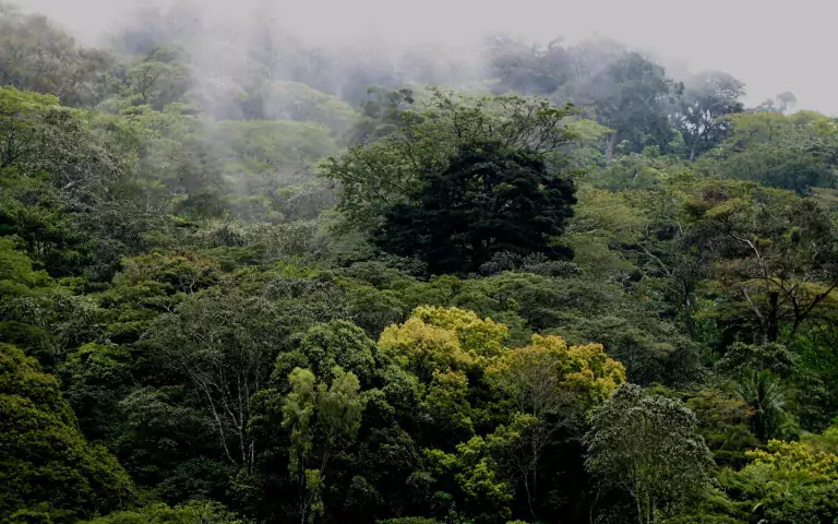
For investigating the water cycle in Africa, the Taita Hills in Kenya offer an excellent location. In this region, a significant share of the water originating in the atmosphere is mist. The forest soil absorbs water more effectively compared to fields or pastureland. Ground litter slows down the flow rate of water, and the roots of trees make the soil porous. When the mist comes into contact with trees, leaves, branches and the mosses that grow on them, they capture the moisture and the water falls to the ground in drops.
– The research group’s findings can be generalised to apply to sub-Saharan Africa, as the Taita-Taveta county can be considered a model of the continent, says Professor of Geoinformatics Petri Pellikka from the University of Helsinki. Because of varied elevation, the landscapes and land types in the region range from arid savanna grassland to humid cloud-covered forests. A total of 60% of the county is a conservation area.
 Fog deposition can produce 20% addition to precipitation when the fog is attached to tree branches and leaves. Without forest this fog cannot be captured.
Greenhouse gas emissions are lowest in natural bushland
Sheila Wachiye, a Kenyan doctoral researcher, will defend her doctoral thesis on greenhouse gas emissions and the land-use types of the Taita-Taveta county on 3 June on the University of Helsinki’s Kumpula Campus. In Wachiye’s doctoral thesis, which is currently being examined, the amount of greenhouse gas emissions released from the soil of near-natural bushland was found to be lower than from areas adopted for other types of land use. These include grazing land, cropland, sisal plantations and savanna grassland in conservation areas. Natural bushlands as a land type also sequester carbon dioxide from the atmosphere, storing it in wood.
The reduction of trees also increased the amount of carbon dioxide in the atmosphere, with fewer trees to bind the compound and at the same time store it as wood.
– We are shooting ourselves in the foot by clearing forests and bushland for food production, Pellikka says. According to Pellikka, the surface temperatures of the soil rise, less water is bound by vegetation and the habitats for insects – the pollinators of agricultural crops – are reduced.
Conservation is not always good
Conservation can also have an adverse effect on ecosystem services. Because of heat, large numbers of mammals, elephants in particular, use the leaves and bark of trees as food in addition to grass, killing the trees. This generates savanna grassland. In the doctoral thesis of Edward Amara from Sierra Leone, the biomass of woody vegetation on both sides of the boundary were compared using laser scanning data. The boundary is steep, with the conservation area offering less biomass and trees as well as biodiversity and habitats for insects pollinating agricultural plants, among others.
Forests are also important producers of volatile gases. When condensed in the atmosphere, these gases act as a nucleus for humidity that ultimately generates rain – if not over the forest, then elsewhere. However, the humid mountain forest patches in Taita are too small to generate rain. Nevertheless, the first white clouds always appear over the forests.
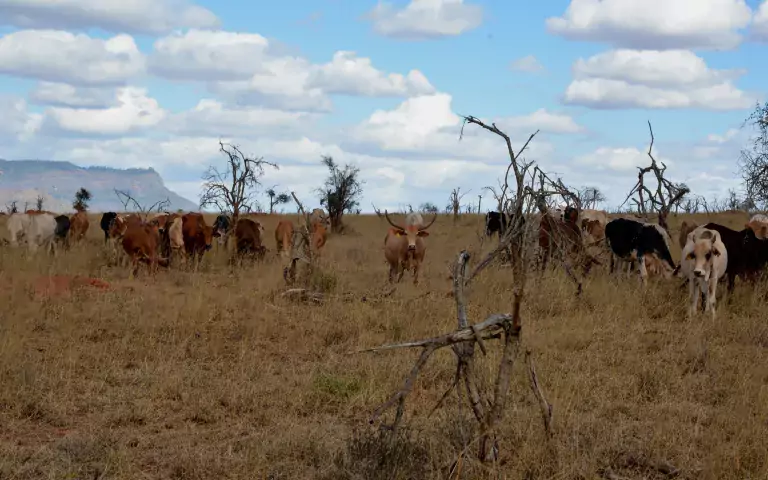
 Cattle grazing in a conservation area, which trees are badly damaged by elephants.
Change in land use accelerates climate change
In SmartLand, a recently concluded project funded by the Academy of Finland, the topic of research was a model of climate-smart agriculture and landscape in the Taita Hills and the surrounding plains. With the help of satellite images, it was found that clearing bushland into open field elevates soil temperatures, with less water evaporating from the field into the atmosphere compared to bushland. In the ongoing ESSA project funded by the European Commission, measurements carried out by Temesgen Abera demonstrated that the clearing of forests and bushland into fields elevates land surface temperatures both during the day and at night, whereas changes in land use elevated surface temperatures only in the daytime. According to Abera’s measurements, the temperature of the land surface averaged 8 degrees lower beneath bushland or the forest canopy than above the canopy measured by satellite in the same location on the Taita plains.
In future, research related to food security will be conducted also at the Taita Research Station. Together with Laura Alakukku and Janne Heiskanen, Pellikka will launch a project investigating the potential for agricultural adaptation to climate change in the different elevation zones of the Taita Hills as well as from the lowlands to the central highlands of Kenya as a whole. The project will be funded by the Academy of Finland.
The findings of Pellikka’s research group are expected to indicate that the loss of natural vegetation increases temperatures in the soil, on the land surface and in the air, while decreasing the sequestration of carbon dioxide from the air by trees and the storing of carbon in vegetation.
The dizzying rate of population growth in Africa necessitates a boost in food production. While elsewhere in the world this is carried out through agricultural technology, the means used in sub-Saharan Africa is the clearing of agricultural land – which, according to research, accelerates climate change. In this light, African agriculture should be intensified not through field-clearing but with irrigation systems, fertilizers and pest control agents, logistics chains, and other technical solutions.
Upcoming public defenses of doctoral theses:
- Sheila Wachiye, 3 June 2022. Soil greenhouse gas emissions from dominant land use types in lowlands and highlands of Southern Kenya.
- Ruut Uusitalo, 7 June 2022. Geospatial risk analysis of disease vectors and vector-borne diseases in boreal and tropical landscapes.
- Zhipeng Tang, 16 June 2022. Gap-filling for image preprocessing and machine learning: implementations and applications in remote sensing
- Edward Amara, 2022. Woody aboveground biomass and its drivers in mosaic landscapes in West and East Africa
- Yang Liu, 2022. Biogenic volatile organic compounds and formaldehyde from East African ecosystems
Original Story Source: University of Helsinki

 Alerts Sign-up