California’s Worst Wildfires Are Helping Improve Air Quality Prediction
New method measures and predicts air quality in areas with insufficient monitoring
UC Riverside engineers are developing methods to estimate the impact of California’s destructive wildfires on air quality in neighborhoods affected by the smoke from these fires. Their research, funded by NASA and the results published in Atmospheric Pollution Research, fills in the gaps in current methods by providing air quality information at the neighborhood scales required by public health officials to make health assessments and evacuation recommendations.
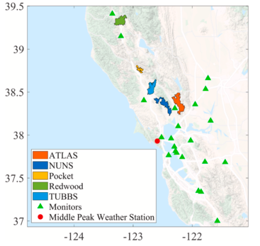
 Map of routine state-agency surface PM2.5 monitors and wildfires in the San Francisco Bay area. (Venkatram et. al, 2021)
Measurements of air quality depend largely on ground-based sensors that are typically spaced many miles apart. Determining how healthy it is to breathe air is straightforward in the vicinity of the sensors but becomes unreliable in areas in between sensors.
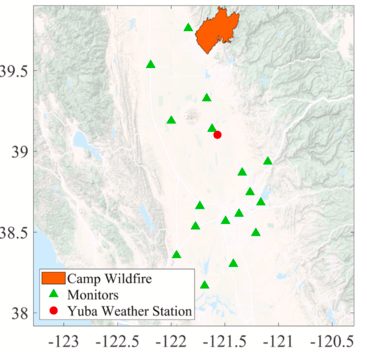
Akula Venkatram, a professor of mechanical engineering in UC Riverside’s Marlan and Rosemary Bourns College of Engineering, directed a group that developed a method to interpret fine particulate matter concentrations observed by ground-based sensors during the 2017 fire complex that included the Atlas, Nuns, Tubbs, Pocket, and Redwood Valley fires, and the 2018 Camp Fire.
Their method fills in the gaps in air quality information obtained from ground-level monitors and satellite images using a mathematical model that simulates the transport of smoke from the fires. This approach provides estimates of particulate emissions from wildfires, which is the most uncertain of the inputs of other methods of interpreting the same data. These emissions combined with the physics embodied in the smoke transport model allowed the group to estimate the variation of particulate concentrations over distances as small as one kilometer.
 Map of routine state-agency surface PM2.5 monitors and fire source in Sacramento Valley. (Venkatram et. al., 2021)
“We need better ways to measure air quality so we can let people know when and where it’s safe to go out and exercise, or go stay somewhere else, for example,” Venkatram said. “In addition to filling in the gaps in the data from monitoring stations and satellite images, our method can also be used to predict the next day’s air quality by estimating wildfire emissions for tomorrow based on today’s observations.”
While any smoke can make air unpleasant to breathe, it is the tiniest particles, called PM2.5, that can penetrate lung tissue and cause the most health problems. The UC Riverside model is specifically designed to predict PM2.5 concentrations in areas with insufficient coverage by air quality monitoring stations.
The authors hope their work will help efforts to protect public health during California’s inevitable annual wildfires.
The paper, “Improving spatial resolution of PM2.5 measurements during wildfires,” is available here. Other authors include Yifan Ding, Isa Cruz, and Frank Freedman.
Publication: Yifan Ding, et al., Improving spatial resolution of PM2.5 measurements during wildfires, Atmospheric Pollution Research (2023). DOI: 10.1016/j.apr.2021.03.010
Original Story Source: University of California – Riverside

 Alerts Sign-up